Fort Clark (Mercer County, North Dakota)
Mercer County · North Dakota · Indian Wars
History & Significance
Fort Clark, named for Captain William Clark, was one of the three major American Fur Company posts on the Upper Missouri River established to deal directly with various tribes. The rectangular fort measured 120 feet by 160 feet and was protected by a palisade, housing the head trader Francis A. Chardon and other fur trade buildings.
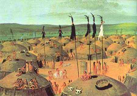
The first steamboat to reach the Upper Missouri, the Yellowstone, arrived at Fort Clark in 1832 with 1,500 gallons of liquor and trade goods, departing with 100 packs of beaver pelts and bison robes. Artists Karl Bodmer and George Catlin and German scientist Prince Alexander Philipp Maximilian of Wied-Neuweid documented life and death at the site in vivid detail.
Cholera in 1851 and smallpox in 1856 further devastated the Arikara population. The fort was abandoned in 1860 when the south half burned. More than 2,200 surface features from houses and graves remain, along with an unmarked cemetery containing more than 800 graves.
Key Facts
Map
View larger map ↗ · © OpenStreetMap contributors
🧳 Visiting
What you’ll see when you visit:
- Archaeological remains of trading post lodges and houses
- Missouri River setting where Mandan and Arikara communities thrived
- 1830s visits by notable artists and explorers documented at site
- Graves and settlement evidence revealing indigenous population history
- American Fur Company trading operations center
Sources
- https://www.history.nd.gov/historicsites/clark/
- https://www.history.nd.gov/historicsites/clark/clarkhistory.html
- https://en.wikipedia.org/wiki/Fort_Clark_Trading_Post_State_Historic_Site
- https://www.hmdb.org/m.asp?m=33313
- https://sah-archipedia.org/buildings/ND-01-ME1
- https://www.oupress.com/9780806154169/fort-clark-and-its-indian-neighbors/
Other Forts in North Dakota
See all forts in North Dakota →