Fort de Cavagnial (North of Fort Leavenworth, Kansas)
North of Fort Leavenworth · Kansas · French and Indian War
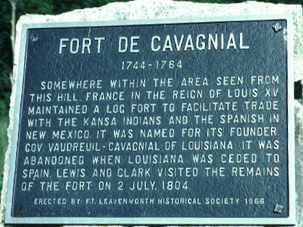
History & Significance
Named for French Louisiana Governor Francois-Pierre Rigaud, baron de Cavagnial, marquis de Vaudreuil, the post was built by trader Joseph Deruisseau, who was granted a monopoly to trade with Indians along the Missouri and Kansas Rivers on August 8, 1744. Its first commandant was François Coulon de Villiers, from an illustrious New France military family.
The fort contained a commandant's house, guardhouse, powder house, trader's house, and employees' quarters, built of logs and covered with mud; at its height, as many as 50 military personnel and civilians occupied it. The fort was the furthest west on the Missouri at the time.
After the French and Indian War, the territory fell under Spanish control, though French soldiers remained until 1764, when authorities ordered them to abandon and "throw down" the outpost and retreat to New Orleans. While Lewis and Clark observed ruins in 1804, all traces were lost by the mid-19th century. The fort's exact location remains an active historical and archaeological mystery in Kansas.
Key Facts
Map
View larger map ↗ · © OpenStreetMap contributors
🧳 Visiting
Sources
- https://www.kansashistory.gov/kansapedia/fort-de-cavagnial/12056
- https://en.wikipedia.org/wiki/Fort_de_Cavagnial
- https://www.nps.gov/places/fort-de-cavagnial.htm
- https://fortwiki.com/Fort_Cavagnal
- https://www.legendsofamerica.com/fort-cavagnial/