Fort McClary (Kittery Point, Maine)
Kittery Point · Maine · War of 1812, Civil War
History & Significance
Military defense of the site dates to 1689, when William Pepperrell acquired the land and erected simple earthworks and a small blockhouse known as Pepperrell's Garrison. The Province of Massachusetts Bay voted in 1715 to erect a permanent breastwork of six guns for the defense of the Piscataqua River.
This fortification was transferred to the United States government in 1803 as Fort William, but the Pepperrells remained loyal to the British in 1775, so local Patriot forces confiscated the property. In 1776, the New Hampshire militia manned the fort until 1779.
When Fort McClary was constructed in 1808, the original breastwork was rebuilt into a large semi-circular granite wall (the Lower Battery) with emplacements for nine guns and a shot furnace. During the War of 1812, Fort McClary served primarily as a recruiting rendezvous and training ground for federal artillery units.
The fort was further expanded in the 1840s as a consequence of tensions with Great Britain over the disputed border between Maine and New Brunswick. Its Civil War garrison notably included Vice President Hannibal Hamlin, who enlisted in Company A of the Maine State Guard as a private and served as a cook in the fort.
The fort saw little action during the Civil War. A major rebuilding and expansion began in 1863 as part of the third system of fortifications, but funding was withdrawn in 1867 because masonry forts were assessed as vulnerable to rifled cannon, leaving the project incomplete.
Key Facts
Map
View larger map ↗ · © OpenStreetMap contributors
🧳 Visiting
What you’ll see when you visit:
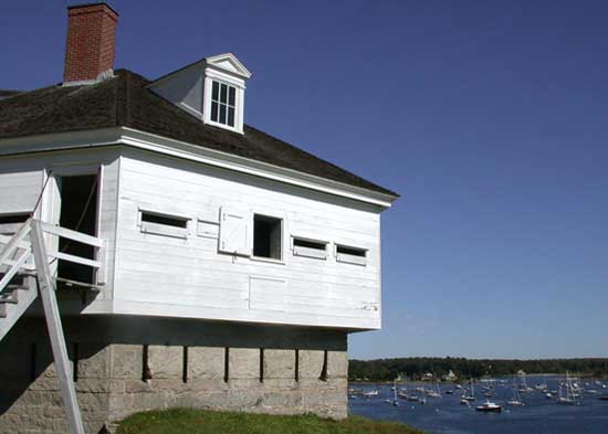
- Renovated 1844 blockhouse museum displaying 19th-century coastal defense history
- Scenic coastal setting overlooking Portsmouth Harbor approaches
- Original earthworks and fortifications from 1808 War of 1812 era construction
- Civil War-era structures and artifacts documenting military occupation
Sources
- https://en.wikipedia.org/wiki/Fort_McClary
- https://www.northamericanforts.com/East/Maine/Fort_McClary/history.html
- https://downeast.com/arts-leisure/road-1812/
- https://www.maine.gov/fortmcclary
- https://apps.web.maine.gov/cgi-bin/online/doc/parksearch/details.pl?park_id=38
- https://www.hmdb.org/m.asp?m=284707
- https://www.pressherald.com/2019/06/30/history-buff-fort-mcclarys-story-spans-several-wars/